Few places remain in the world like Bolivia, a quite isolated country facing enormous socioeconomic challenges that have impaired its development. As a result of the country’s feeble growth, most of its natural environment remains unexploited. Here, it is still possible to experience Earth, as it might have been ages before human intervention. The geography of the country exhibits a great variety of terrains and climates and embodies one of the highest biodiversity in the world. The country is divided into a mountainous western area, with extraordinary altitude, and eastern lowlands, covered by extensive rainforests reaching out to the Amazon. The Bolivian region has been occupied for over 2,000 years and is believed to be the cradle of the Inca. Today, there are about three-dozen native groups and nearly 30 different languages are spoken.
I’ve wanted to visit Bolivia for several years as part of my ongoing interest in visiting extreme natural environments but, for years, I had concentrated my attention on Saharan Africa, a region of expansive immaculate environments traveled by few other than nomadic tribes. In the last several years, the Sahara has fallen hostage to radical Islamic militants making travel in the area very dangerous and uninspiring. Bolivia’s Altiplano appealed to me as an alternative of such extreme environments.
From the beginning, I had a good idea of what areas I wanted to explore but I recognized the importance of traveling with a guide that knows the region and can handle the complex logistics required in expeditions of this kind. My research led to a Bolivian landscape photographer who had vast experience taking geologists and film crews to the most isolated areas of the Altiplano, Sergio Ballivian, who helped plan the itinerary, built the team and conducted the fifteen-day expedition with professionalism and efficiency. Traveling in the area proved to be difficult and unpredictable due to a massive strike of miner workers that had blocked the few available roads in the region. We adjusted our intended route using only primitive four-wheel trails leading to the main areas we had originally planned to visit, this worked for the North-South section of the trip, but the return route to La Paz was blocked by the strike and forced us to fly out from the small town of Uyuni.
Our group arrived to La Paz a couple of days before the intended departure date to adapt our bodies to the extreme altitude of the Altiplano, averaging 16,000 feet. We landed in the El Alto airport at 13,000 feet, but descended promptly to lower La Paz at 10,000. I found the geography of the city to be interesting to the eye, but experiencing it was disappointing. The city runs in chaos and anarchy. Other than a few sites, La Paz is a forgettable city nestled in a valley framed by striking mountains. There are only a few sites worth visiting, such as the Witches Market, where herbs, remedies and ingredients for Ayamara rituals and traditions are sold in picturesque stands. I was also stroke by the San Francisco church, a beautifully preserved colonial building with fascinating interior altars bursting with lively worshippers.
 Once we had our lungs accustomed to the altitude, we took a couple of one-day excursions to nearby sites. The first one was to a high-section of the Yungas, a transitional region that links the eastern slopes of the Andes with the Amazonia tropical rainforest in the north of the country, dropping nearly 11,000 feet in one day. The road we traveled on, known as the Death Road, is a legendary single-lane dirt route that winds through steep hillsides flanked by steep lush slopes, bathed by waterfalls and fog. We travelled as far as the town of Coroico and returned to La Paz that night.

The next morning we headed to our second one-day excursion to Titicaca, the highest navigable lake in the world, at 12,000 feet. The lake was an obligated visit, but not the central reason for our trip to that area. Our main destination that day was Tiahuanaco, an archeological site regarded as the place of origin of one of the most important civilizations prior to the Inca Empire. Among the ruins of the ancient city there is a megalithic stone arch, called the “Gate of the Sun”, built over 1500 years ago. What brought us to this Gate was the will and mandate of
 our dear friend David Quintero, who had pledged to his Bolivian father-in-law that, someday, he would spread his ashes through the gate. With profound love and ceremonial protocol, David fulfilled his father-in-law’s wish in a ritual that will forever remain in my memory. That night we returned once again to La Paz in preparation for an early departure to the Altiplano.
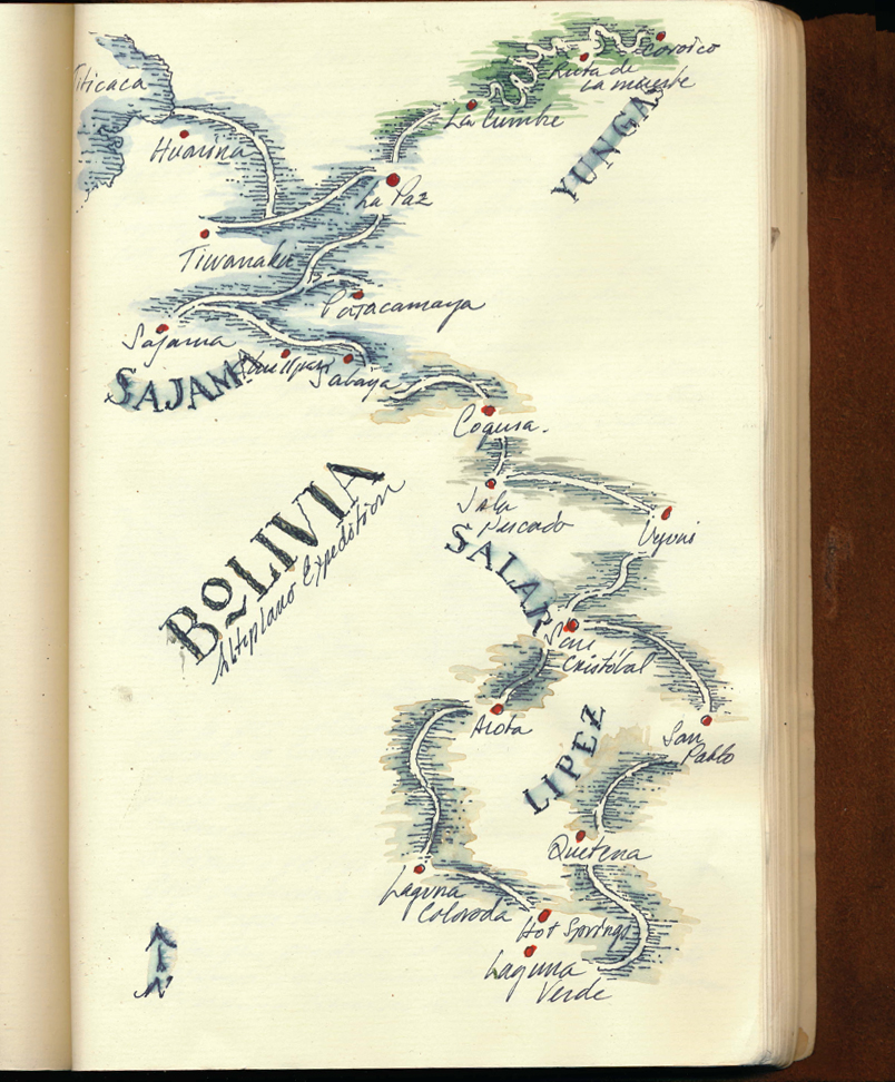 The magnificence of the Altiplano landscape became quickly clear shortly after leaving La Paz. The road to Sajama displays spectacular volcanoes and vast pampas s
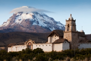 cattered with llama and isolated rural dwellings. Mt. Sajama is the highest peak in Bolivia at 21,500 feet and, it dominates the landscape with its beautiful volcanic crest and snow-covered skirt. The mountain is a perfect subject for sunset, offering a spectacular display of rolling clouds that blend the warm colors of the setting sun with the golden patina of the surrounding landscape. We spent the night at the foot of the volcano in a small Aymara village called Tomarapi.
 We got an early start the next day heading south towards the village of Tahua, at the northern shore of the great Uyuni salt sea. The road had very interesting natural and archeological features. We saw a series of chullpas, ancient funerary towers, some dating back 1,000 years. Some chullpas are unadorned and others have perfectly preserved color adornments on the façade. In all cases, the openings of the tomb faces the rising sun and continue to hold the corpse of the deceased and their belongings after many centuries. The Altiplano is an area of inland drainage similar to the Tibetan Plateau only dominated by massive active volcanoes and regarded as one of the driest areas on the planet. Regardless of its dryness and altitude, The Altiplano boasts an enormous variety of flora and fauna. Among the most interesting ones is Llareta, an ancient evergreen that grows only 1 cm per year and lives as long as 3,000 years.

Tahua is an agricultural village on the north shore of the salt sea at the foot of a massive volcano crowned by a multi-colored crest. What we found appealing about this village was the site of the bright red quinoa fields contrasting against the vast white landscape of the Uyuni Sea. From Tahua we entered the Salar de Uyuni, the main destination in our expedition itinerary.

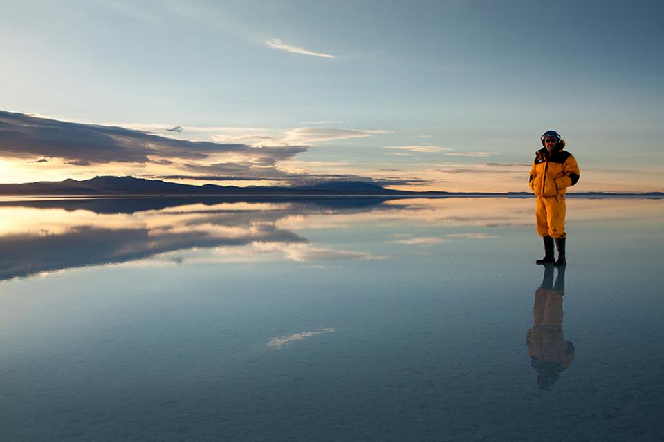
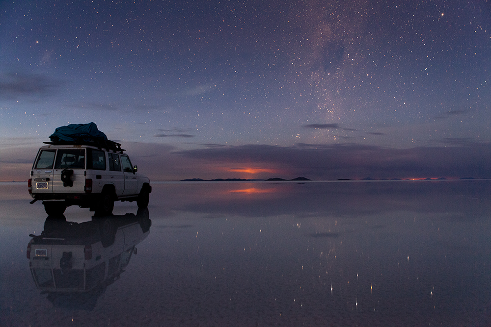
The Salar de Uyuni is a unique spectacle. This massive 4,000 square-mile prehistoric lake, now covered with a few meters of salt crust, is so flat that most Earth-observation satellites use it to calibrate their altimeters. It can only be explored in four-wheel vehicles with experienced drivers. One may travel for days surrounded with nothing other than salt and small remnants of coral reefs that use to be in the bottom of the ocean millennia ago and now serve as isolated bio-systems housing endemic flora and fauna. These islands rise in a stark oxide-color from an elegant carpet of pristine white salt. We camped at Isla Pescador, one of the most remote of the islands, we arrived at the end of the day just before the sunset lid up the expansive landscape in violet and orange colors laced in the intricate polygonal patterns formed on the salt surface. Camping in the middle of this extraordinary landscape is a profound experience, especially at 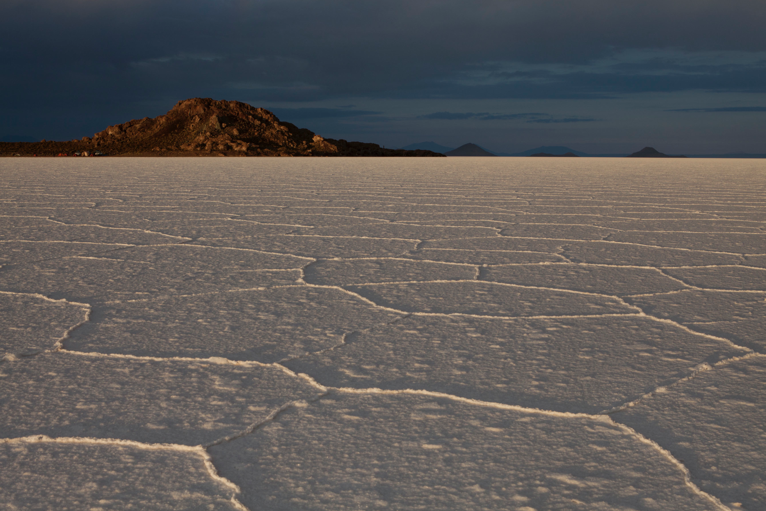 night, when the southern star dome shines in exquisite brightness and detail. During the night, I took a three-mile walk away from the campground to enjoy the solitude and awe that one can only experience in the most extreme of natural environments, such as floating in the middle of the Pacific Ocean, or walking on the ephemeral sands of the Saharan Ténéré. The Salar de Uyuni can be visited at different times of the year for completely varying effects, but we chose to explore the area at the very end of the rain season when a thin layer of water extending for several miles reflects, in pristine detail, everything that happens in the sky. This fantastical symmetries are dramatically painted in the colors of sunrise and sunset, but astonishingly, it is at night when the effect is unimaginable – the Milky Way is neatly displayed above and bellow as if there was no horizon.
The southern area of the Altiplano is mostly a rocky plateau displaying dramatic rock formations. The landscape is staged by iconic volcano cones painted in every shade of mineral colors, from a deep burnt sienna to a pale yellow. There is hardly any vegetation in this expansive region other than Llareta, that grows like emerald-green jewels delineating boulders and crevices. In route to the south, we stayed at a small hotel located 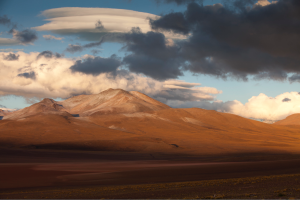 in a striking valley isolated from absolutely everything or everyone. From the porch of the hotel we had a view of the great mountain range in the northwestern region of Sud Lipez, a perfect view to enjoy the sunrise. The trail led us through active volcanic vents that continually splatter gas and mud rich in sulfur. This stretch is at an average height of 14,000 ft and some of us had symptoms of hypoxia due to the lack of oxygen.

The arrival to Laguna Colorada is breathtaking. From a distance the immense lagoon looks like a gigantic colorful painting in shades of red and silver. Its name refers to the color of the water, a deep pink color caused by pigmentation of algae and rich minerals that flow into the lake. This  is home for the Andean flamingo, one of the rarest in the world. This southernmost region features another spectacular lake, Laguna Verde, painted in crisp turquoise green framed by a dry salt shore. The water gets its intense color from chemicals and minerals that flow from the surrounding mountains, such as Mt. Llicancabur, a towering volcanic cone rising to 19,000 feet above sea level.
Visiting this region of Bolivia is not for the weary kind. There is little travel infrastructure and travel distances are very significant. The lack of adequate oxygen increases fatigue and causes a bit of a temperament edge. Yet, those who venture into it are treated to some of the most powerful spectacles offered by Mother Nature, from the reflective symmetries in the Uyuni landscape, to the luminous stars in the southern night sky, Bolivia has a deserved place among the ten most beautiful places to visit on Earth.

It was a pleasure traveling with a group of dear friends with whom I share a profound appreciation of extreme natural environments: David Quintero, Benito Martínez, Rene Goiffon, Adrian Velicescu and Nacho Prado. I’m grateful for their friendship.